Gialos Beach Lefkada: 4km Shore, Car Only, North of Katsiki


Profile
Gialos Beach, Lefkada: The 4km Second-Longest Beach on the Island, North of Porto Katsiki and Egremni, Reached by a Narrow Winding Road That Boats Cannot Bypass Because of the Rocky Seabed
Greece | Athani | Lefkada, Ionian Islands
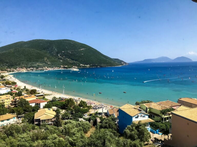
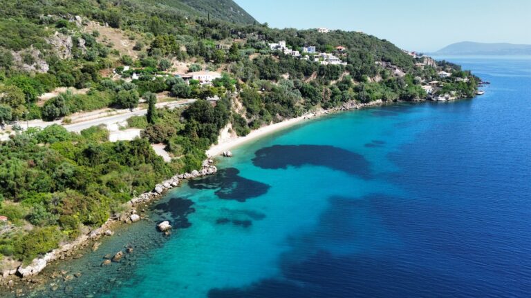
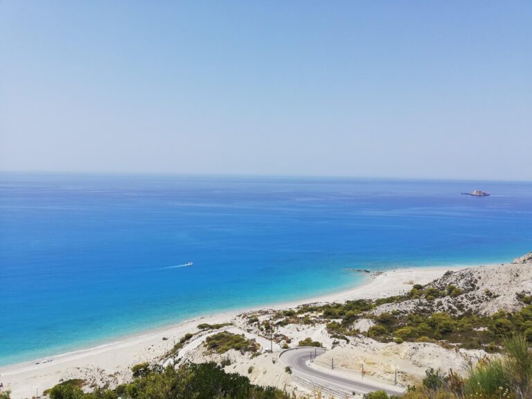
The west coast of Lefkada is the version of the island that exists in most photographs: vertical white limestone cliffs descending to turquoise water, the open Ionian horizon visible from heights of 200 metres, the light specific to a coastline facing west into the late afternoon sun. Porto Katsiki is the most photographed. Egremni is the longest beach. Gialos is north of both, less photographed, longer than most visitors expect, and specifically different from its famous neighbours in one way that every practical guide notes: no boat trips reach it. The seabed approaching Gialos is shallow and rocky, which makes anchoring impossible and means that every visitor arrives by the same narrow winding road from Athani village, 4 kilometres above.
The 2015 earthquake — a magnitude 6.5 event that struck Lefkada on 17 November 2015 — damaged the access road to Gialos significantly. The road was impassable for a period and remains a specific navigational challenge: steep, winding, narrow, with tight turns and sections still subject to surface deterioration. The descent to the beach from the Athani turnoff is the experience that visitors describe before they describe the beach itself. Multiple sources characterise it as narrow and challenging, requiring slow careful driving. The view opening up at the bottom — the 4-kilometre sweep of beach and the turquoise Ionian — is the specific reward that makes the approach worthwhile.
Gialos is 3.9 to 4 kilometres long — the second longest beach on Lefkada after Egremni, and one of the longer beaches in the Ionian Islands. The beach is sand and small pebbles, with a normal rather than gradual depth increase. Aqua socks are recommended. The western orientation means the sunset is directly into the sea — the same quality that makes every west coast Lefkada beach photogenic at the end of the day, applied to a beach with enough length to walk off the crowd.
Getting There: 36km From Lefkada Town (59 Minutes), 16km From Vasiliki (37 Minutes), Narrow Winding Road From Athani — No Boat Access
From Lefkada Town, drive south toward Vasiliki and continue on the west coast road through Agios Petros and mountain villages to Athani. From the Athani turnoff, a narrow winding road descends 4 kilometres to the beach. Total distance from Lefkada Town: approximately 36 kilometres, 59 minutes. From Vasiliki (covered in this series), the distance is 16 kilometres, approximately 22 kilometres by road, 37 minutes.
The road from Athani requires full attention. It is narrow, steep, and has tight hairpin turns. Meeting an oncoming vehicle at certain points requires one car to reverse to a passing point. Driving slowly is not optional — it is the only safe pace. Scooters and small cars manage it; large vehicles are not recommended. The view of the beach from the road as it descends is described consistently as one of the most beautiful first views in the Ionian.
No boat excursions from Lefkada port or Nydri serve Gialos — the shallow and rocky seabed prevents anchoring. The beach is car-access only. This is the specific reason it remains less visited than Porto Katsiki, which boat trips reach from multiple ports.
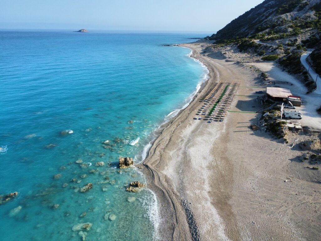
The Beach: 4km, Sand and Small Pebbles, Mostly Unorganised, Aqua Socks Recommended, Cactus Kantina and Fresco Restaurant Near the Parking Area
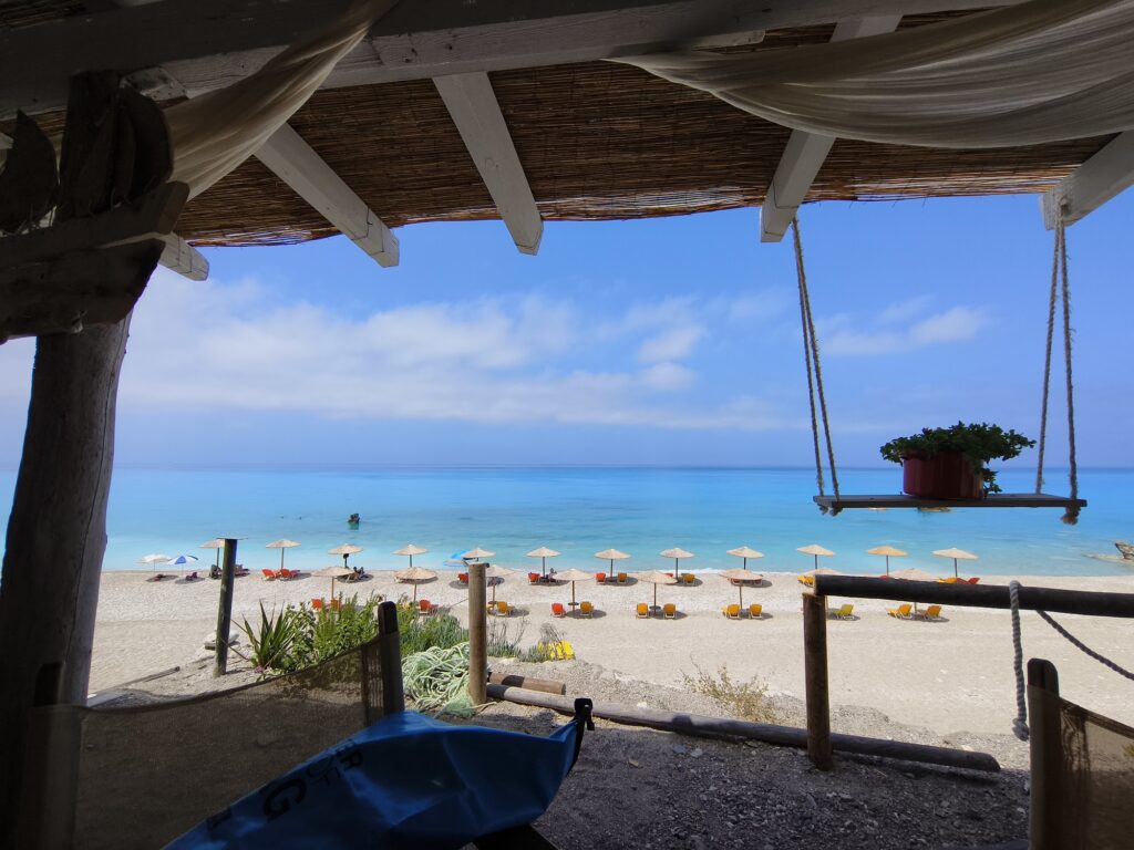
The parking area is at the beach level — a flat parking space directly behind the sand, unusually accessible compared to the cliff-descent beaches nearby. From the parking, the central organised section has sunbeds and umbrellas from Cactus Kantina and Fresco Restaurant (the two specific beach establishments named in independent guides). The consumption model applies: a purchase covers the sunbed use.
The vast majority of the 4 kilometres is unorganised — no sunbeds, no umbrellas, no infrastructure. Visitors who want solitude walk north or south from the parking area until the crowd thins. In August, the organised central section can be busy; the sections 500 metres in either direction are consistently quieter. In July, the entire beach is less pressured.
Water shoes are specifically recommended by multiple independent sources — the entry is “normal” rather than gradual, and the rocky patches make barefoot entry uncomfortable in certain sections.
The West Coast Sequence: Gialos, Egremni, Porto Katsiki — the Three Cliffs
Gialos is the northernmost of the three major west coast beaches. Egremni — the longest on the island, accessible by 350 stairs or by boat, damaged by the 2015 earthquake (its cliffside partially collapsed) — is immediately south. Porto Katsiki — the most photographed beach in Lefkada, accessible by stairs or boat — is the southernmost of the three. All three are on the same limestone cliff coastline, all facing west, all producing the same turquoise water from the same white limestone seabed reflection.
The comparison that matters for visitors choosing between them: Porto Katsiki for the most dramatic setting and boat access; Egremni for the longest beach and the stairs experience; Gialos for the most accessible parking, the car-only isolation, and the 4 kilometres of largely unorganised space that August crowds cannot fill.
Athani Village: The Service Base 4km Above the Beach
Athani is the nearest village to Gialos — 4 kilometres up the hill, with family-run guesthouses, traditional tavernas serving grilled meats, Eglouvi lentils (the protected product from the mountain village 10 kilometres northeast, used in salads and stews), and local wine. The village has the specific character of a mountain farming community on the high plateau above the west coast — it grows olives, produces local food, and services the visitors who make the descent to the beaches below.
Eglouvi lentils (Fakes Egklouvis) — small, dark, intensely flavoured lentils from the mountain village of Eglouvi on Lefkada — carry a Protected Geographical Indication. They are served in Athani tavernas and throughout Lefkada and are a specific product that distinguishes the island’s food culture from mainland cooking.
The Sunset: Directly Into the Sea, Visible From the Beach Level
The west coast orientation of Gialos delivers the sunset directly into the Ionian rather than behind hills or over a channel. From the beach level — which is where the flat parking area and the beach bars position you — the sun’s descent is unobstructed and visible from start to finish. The specific quality of the Lefkada west coast sunset is well-documented in travel accounts: the limestone cliffs turning orange, the turquoise water shifting colour with the light, and the specific moment when the sun touches the sea horizon.
We has covered Vasiliki Beach Lefkada Greece — the windsurfing bay on the south coast where the thermal wind Eric builds daily. Lygia Beach Lefkada Greece — the east coast fishing village with the St George fortress on the mainland visible across the strait — offers the opposite character from Gialos: calm, sheltered, harbour-front. The contrast between the two versions of Lefkada is as clear as the contrast between east and west.
Gialos Beach on Lefkada is the 4-kilometre second-longest beach on the island — sand and small pebbles, aqua socks recommended, car-only access via narrow winding road from Athani village (no boat trips, rocky seabed), flat parking directly at the beach, mostly unorganised (the organised section with Cactus Kantina and Fresco Restaurant is central), the majority of the 4km unoccupied even in August, the sunset directly into the Ionian, north of Porto Katsiki and Egremni on the same limestone cliff coast, 36km from Lefkada Town (59 minutes), 16km from Vasiliki (37 minutes).
Take the west coast road from Vasiliki. Turn at Athani. Drive down slowly. Walk north until the beach empties.

Map
Sorry, no records were found. Please adjust your search criteria and try again.
Sorry, unable to load the Maps API.
Near by places: