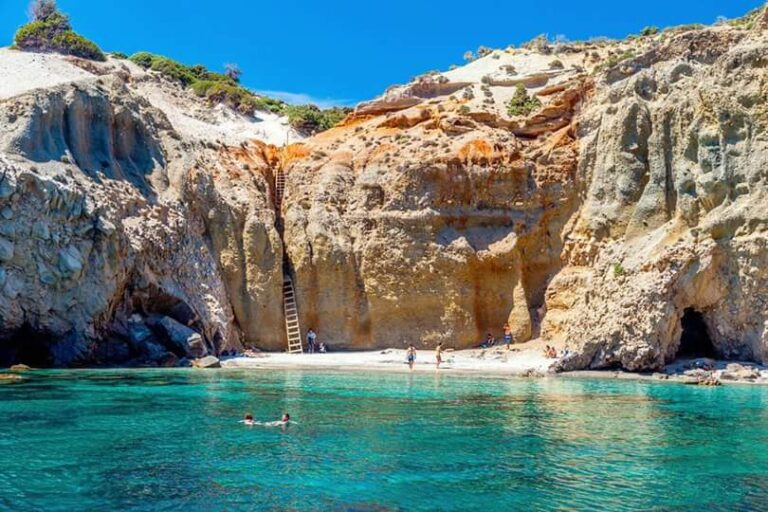
Sarakiniko Beach Milos: Greece's Most Photographed Shore
Profile
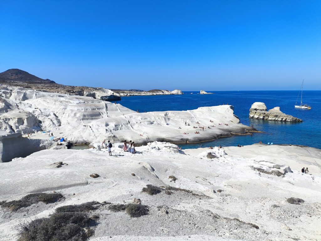
Sarakiniko Beach, Milos: The Most Photographed Beach in Greece, Named After Pirates, With a 2003 Shipwreck in the Snorkelling Zone
Greece | Milos | Cyclades
The music video for Kungs 2016 song “This Girl” was filmed at Sarakiniko. The video accumulated over a billion views. The beach was relatively quiet before that. After that, it became the most photographed beach in Greece, and the crowds arrive early — by 9am on a summer morning, the parking lot is filling and the prime positions on the white rocks are taken.
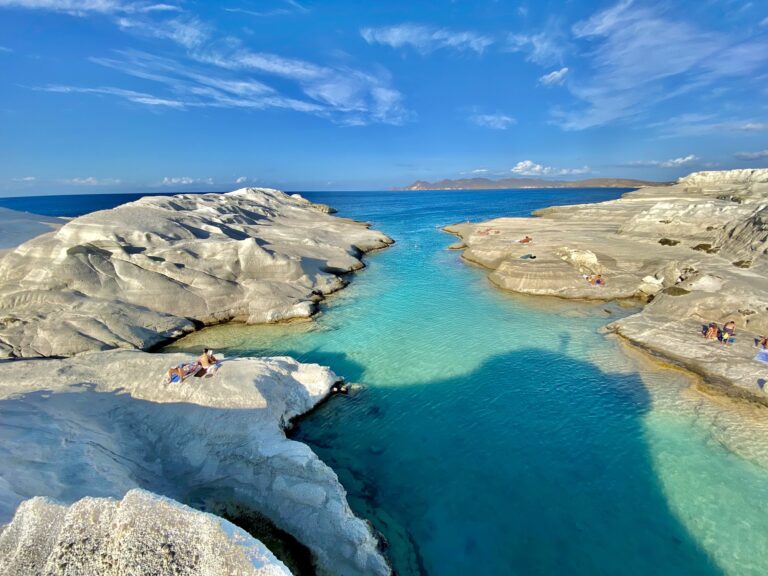
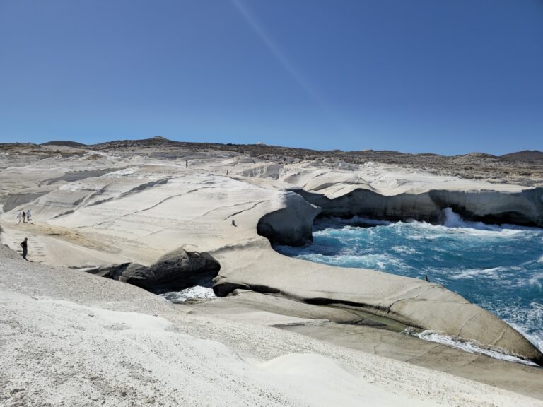
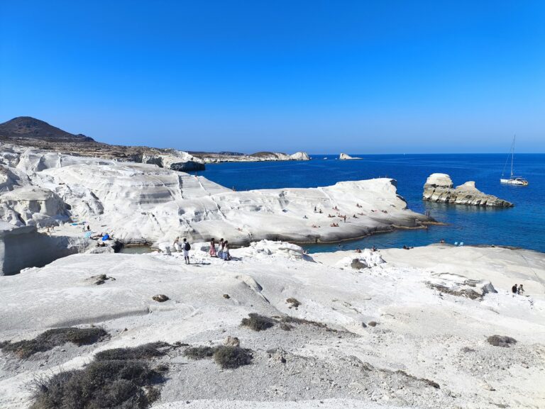
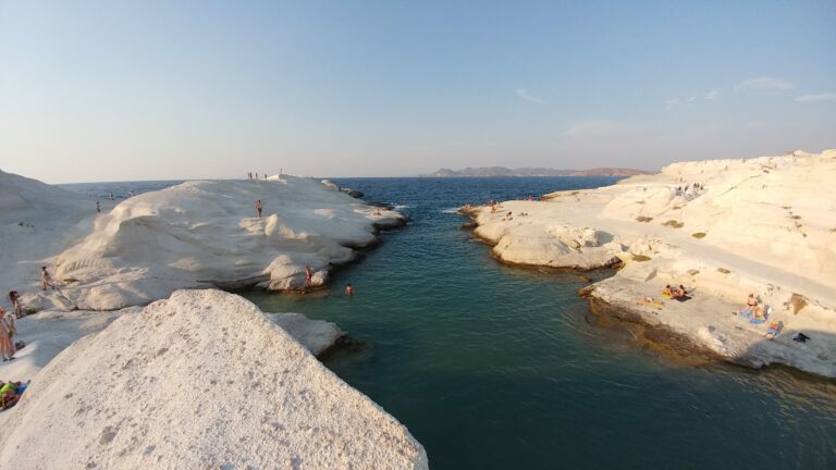
Sarakiniko Beach is on the north coast of Milos, approximately 4 kilometres from Adamas port. The landscape is formed from deposits of volcanic pumice, tuff, ash, and lava produced by the eruptions of the Hellenic Volcanic Arc that created Milos and the surrounding islands. The deposits were eroded over millennia by the Meltemi wind and the sea, creating the smooth white sculpted forms — undulating platforms, arched caves, narrow channels, and hollowed tunnels — that produce the “lunar landscape” comparison that every account of the beach reaches for.
The name comes from the Saracen pirates who used the caves as shelter — later Cilician, Ottoman, and Barbary pirates also occupied the coast. The pirate history and the geology are the two threads that run through the beach’s character: nature shaped it, and the people who came to hide in it named it.
Getting There: 4km from Adamas on the Main Coastal Road, KTEL Bus 3 Times Daily, Arrive Before 9am
From Adamas port, take the main coastal road north. The turn-off for Sarakiniko is clearly signed, approximately 4 kilometres from the port — approximately 10 minutes by car. The road is fully paved and the parking area at the beach is large and unpaved.
By KTEL bus, the service from Adamas central station includes Sarakiniko on its route. The bus passes approximately 3 times daily in summer — check the schedule before relying on it and note the return times. The bus from Adamas takes approximately 10 minutes.
By sea, catamaran and boat tours from Adamas include Sarakiniko as a swimming stop, allowing the approach from the water that gives the full visual of the white cliffs rising from the Aegean. The sea approach is the most dramatic arrival.
The 9am rule is absolute for July and August: arrive before 9am for quiet photographs and a choice of position. After 9am the crowds build quickly. The alternative: arrive at sunset, when the light is perfect for photography and the day visitors have left.
The Geology: Pumice, Tuff, Volcanic Ash, Wind Erosion Over Millennia
The distinctive white rock formations at Sarakiniko are composed of volcanic pumice — a light, porous rock formed when frothy lava cools rapidly and traps gas bubbles. The surrounding deposits include volcanic tuff and ash layers, visible in the horizontal banding that gives the formations their distinctive layered appearance.
Sarakiniko marks the end of a gorge lined with tamarisk trees. Volcanic rock used to be mined here — old tunnels are visible in the cliff face, remnants of the industrial extraction that continued until the modern era. The beach exists partly because the mining operation left accessible cliff faces that the subsequent erosion shaped into the formations visitors see today.
The Hellenic Volcanic Arc — the chain of volcanic islands that includes Milos, Thera (Santorini), and Nisyros — was formed by the subduction of the African tectonic plate beneath the Eurasian plate. Milos is among the most geologically active islands in the chain and has the most visible volcanic landscape of any inhabited Greek island.
The 2003 Shipwreck: Snorkelling and Photography in the Rocks
A tanker crashed into the rocks at Sarakiniko during a storm in 2003 and is now a fascinating snorkelling and photography spot. The wreck — partially visible at the surface, partially submerged — sits in the channel adjacent to the main rock area and is accessible by swimming from the beach.
The wreck has been colonised by marine life in the 20 years since the grounding and the snorkelling around it combines the industrial archaeology of the vessel with the fish habitat that the sheltered metal structure now provides. The combination of the lunar volcanic rock above water and the shipwreck marine habitat below it in the same location is the specific Sarakiniko quality that distinguishes it from all other beaches in this series.
The Practical Realities: Burning Rocks, Slippery Surfaces, No Shade, Cats
Due to the sun’s reflection, Sarakiniko gets very hot during the day and there’s little shade for cover. The rocks are burning hot at midday — footwear is essential throughout the visit, not just at the water entry. The smooth pumice surfaces look dry and grippy but become slippery when wet. Sturdy sandals throughout, no flip-flops.
There is a small sandy cove within the main rock area — a sheltered inlet where the water is shallow and calm enough for children. The deeper water in the main channel and at the cliff edges deepens quickly. The cliff-jumping positions are used consistently but require personal assessment of the specific jump and the water below before attempting.
Cats. A small group of strays is fed daily by tourists on the beach. They are present and social.
No permanent facilities. A canteen/food truck operates near the parking area in peak season. Bring water, food, sun protection, and footwear.
The Caves and the Pirate History
The caves at Sarakiniko are navigable with a torch — the main caves are large enough to walk into, and the sea tunnels connect some of the inlets at low water. The Saracen pirates who named the beach used the cave network for shelter and concealment — the bay’s position on the exposed north coast, with multiple entrance points and caves deep enough to hide vessels, made it operationally useful.
Other pirate populations — Cilician, Ottoman, and Barbary — used the same coast through successive centuries. The beach’s name is a reminder that the Aegean was piracy territory for most of its recorded history, and that the white rock formations that now host Instagram photographers previously hosted people who needed to disappear.
Kleftiko and the Milos Beach Context
Kleftiko — the other famous beach on Milos, accessible only by boat, also named after pirates (kleftes means thieves) — is the second Milos beach in this series. Kleftiko is the boat-tour equivalent of Sarakiniko: white volcanic rocks, sea caves, turquoise water, pirate history. The difference is access — Kleftiko is boat-only and on the southwest coast, while Sarakiniko is road-accessible on the north.
Sarakiniko Beach on Milos is the most photographed beach in Greece — white pumice lunar landscape formed by volcanic eruptions and Meltemi erosion over millennia, named after Saracen pirates who sheltered in the caves, a 2003 shipwreck in the snorkelling zone, rocks burning hot at midday, no shade, no sunbeds, no permanent facilities, arrive before 9am in summer or at sunset, cats fed by tourists.
The Kungs music video brought the crowds. The geology was there long before the music video.


Map
Sorry, no records were found. Please adjust your search criteria and try again.
Sorry, unable to load the Maps API.
Near by places: