Gianiskari Beach Araxos: Wild Tip of the Peloponnese


Profile
Gianiskari Beach, Araxos: The Northwesternmost Publicly Accessible Beach on the Peloponnese, 45km From Patras, Where the Hillsides Are in Post-Fire Recovery and the NATO Military Zone Begins Immediately to the North
Greece | Akrotirio Araxos | West Achaia, Western Peloponnese
The name descends from medieval Greek. Gianiskari is a paraphrase of Gialiskari, itself a diminutive of Aigialos — the ancient Greek word for seashore. The diminutive ending renders it “the little seashore,” which fits the scale of the beach: a small sandy bay between two hills at the northwestern tip of the Peloponnese, where the Achaia coast rounds the corner and begins to descend south toward Ilia. North of the beach, the land is a restricted military zone — the NATO and Greek Air Force installation at Araxos, whose runways and support buildings are visible on the hillsides immediately beyond the beach perimeter. The military base defines the northern boundary of publicly accessible coastline on this peninsula. Gianiskari is the last beach before the perimeter wire.
The road to get there has improved over the years. It was previously described as one of the most inaccessible beaches in Achaia; the approach now involves a partly paved road that climbs the hill from Akrotirio Araxos village, passes through a narrow section, and descends to the beach between the two hills. A standard car manages it in dry conditions. The approach repays the effort: the bay opens below the road on the final descent, and the combination of the clear turquoise water and the sandy shore enclosed between the hill faces is the reward.
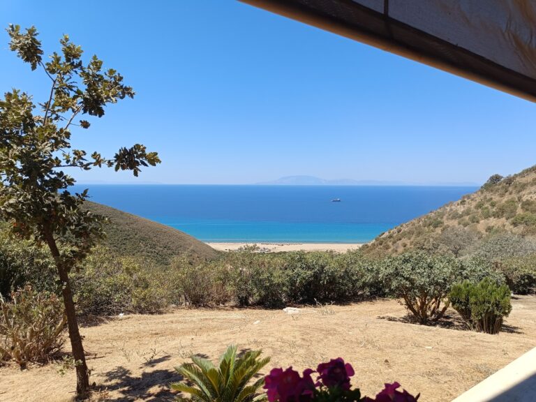
The hillsides around the beach are in post-fire recovery. Four fires — in 2011, 2012, 2014, and 2017 — burned the kermes oak and Mediterranean scrub vegetation from the surrounding hills. The vegetation is regenerating, but the canopy that once shaded the beach approaches is gone. The beach itself is open and sun-exposed throughout the day. A personal umbrella is not optional — it is the primary shade source. Arriving with adequate water and sun protection for a full day is the practical requirement.
Getting There: 45km From Patras, Partly Paved Road From Akrotirio Araxos Village, Standard Cars in Dry Conditions, Arrive Before 10am on Weekends
From Patras, take the road southwest toward Araxos (approximately 29km). After the village of Araxos where the military airport is located, continue to Akrotirio Araxos village. The beach access road begins at the village — it climbs, narrows, then descends to the beach. Total distance from Patras: approximately 45 kilometres, 40 to 50 minutes.
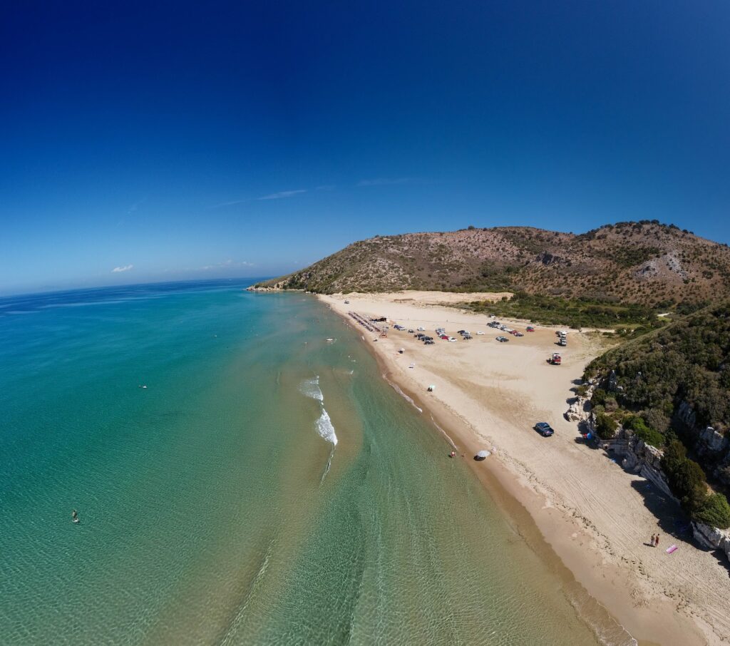
The beach is gaining popularity among Patras area residents and parking fills on summer weekends. Arriving before 10am is the consistent advice. There is no public transport — a car is essential.
The Beach: Sandy, Clear Ionian Water, Bay Between Two Hills, Canteen Only, Open Sun-Exposure, Free Parking
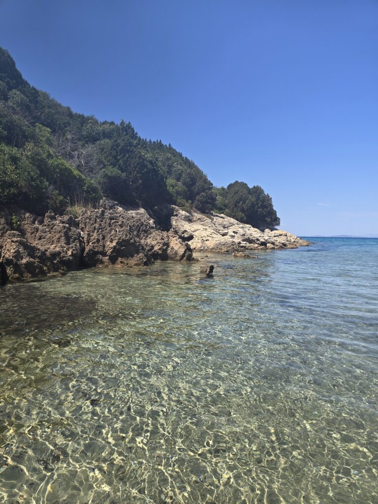
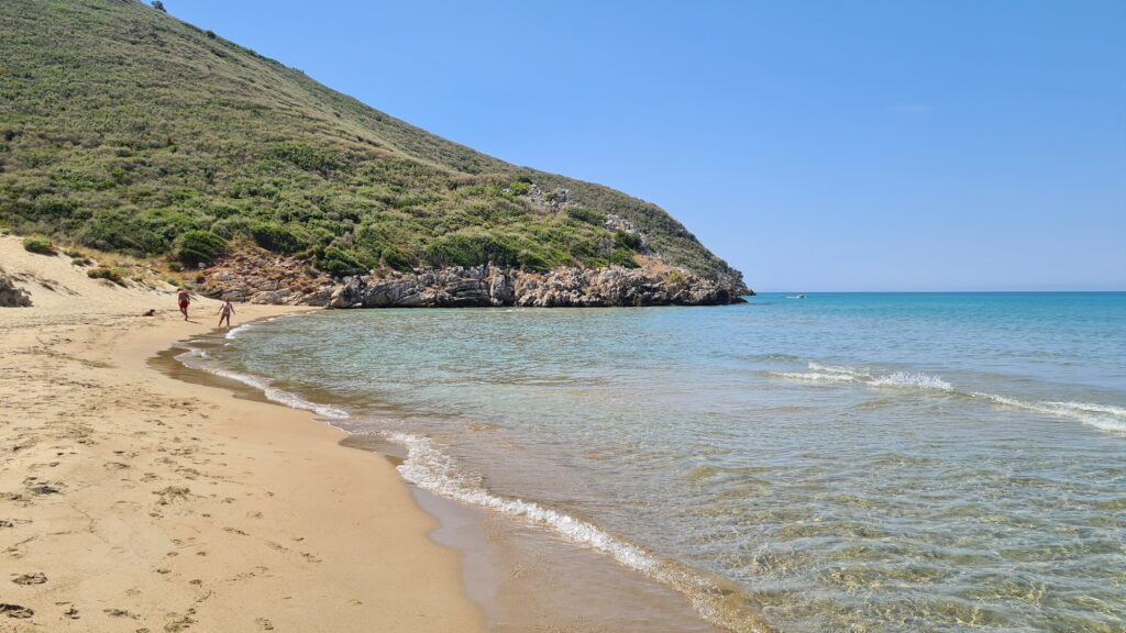
The sand is fine and golden. The bay is enclosed enough between its two hills to reduce wind on most days, though the open Ionian exposure means westerly wind brings waves. The water is clear and turquoise, the seabed sandy with a gradual initial depth increase.
The only facility is a seasonal canteen/beach bar — cold drinks, snacks, and sunbeds. No showers, no changing rooms in the main descriptions. Free parking at the road end. The beach has no permanent lifeguard confirmed in independent accounts — verify seasonal arrangements before visiting with non-swimmers.
The hillsides on both sides of the bay show the post-fire recovery pattern: low scrub returning, the taller oak canopy absent. This is the current landscape. Visitors who stay away from the canteen section find open pebble and sand with no overhead shade. An umbrella packed in the car before leaving Patras is the single most useful preparation.
The Northwesternmost Beach: The Military Zone and the Geographic Significance
Cape Araxos (Akrotirio Araxou) is one of the four major capes of the Peloponnese — along with Malea, Tainaron, and Akritas — that defined ancient navigation in the Ionian and Aegean. The cape was a significant landmark for ancient sailors moving between the Adriatic and the Corinthian Gulf. The Araxos military installation occupies the cape itself; Gianiskari beach is on the southeastern face of the cape’s hill, the last accessible beach before the restricted zone begins.
The specific geography — open Ionian water, the cape as a navigation landmark, the military base where ancient settlement once stood — gives Gianiskari a layered character that its small size does not suggest.
The Dymaean Wall: 4km Southeast, Prehistoric Acropolis Attributed to Heracles
The Dymaean Wall (also Teichus Dymeon, also Kalogria Castle) is 4 kilometres southeast of Gianiskari — a prehistoric acropolis in the territory of ancient Dyme, one of the twelve cities of ancient Achaia. Ancient sources attribute the wall to Heracles when he made war against the Eleans. The actual construction is Mycenaean or early Iron Age in date. The wall sections remain visible on the promontory. The combination of the military-restricted cape and the prehistoric fortification on its southeastern approach suggests that this specific headland has been understood as strategically significant for at least 3,000 years.
The Papa (Araxos) Lagoon: Adjacent to the Beach, One of the Wetlands the Vatican Was Historically Supplied From
The Papa (Araxos) Lagoon lies adjacent to the Gianiskari and Araxos area, the northernmost water body in the Kotychi-Strofylia wetlands complex. The name Papas — pope — reflects a tradition recorded in Byzantine sources: the lagoon’s sea bream were offered as a gift to the Vatican, and the papal connection gave the lagoon its name. The lagoon is a traditional fish farm, operated by local fishermen using retractable nets, supplying the tavernas of Araxos and the surrounding villages.
Kalogria and the Strofylia Forest: 8km South, Where the Umbrella Pines Reach the Beach
The Strofylia Forest — 20,000 acres of umbrella pine (Pinus pinea) with some individual trees over 200 years old, one of the largest umbrella pine forests in Europe — is at Kalogria beach, 8 kilometres south of Gianiskari. Kalogria is the beach where the forest reaches the waterline, where the sand dunes are most developed (the impressive northern dunes are in the Gianiskari direction), and where the Kotychi-Strofylia National Park infrastructure with its eight hiking trails and three cycling routes is based. The Vatican sea bream connection extends there too — the fish farm tradition of the Papa Lagoon, Prokopos Lagoon, and Kotychi Lagoon covers the full coastal wetland system.
Visitors who want a pine-shaded beach with the full forest backdrop should continue south to Kalogria. Gianiskari is the exposed, uncrowded, harder-to-reach cape beach at the northern end of the same protected coastline.
Gianiskari Beach at Cape Araxos in West Achaia is the northwesternmost publicly accessible beach on the Peloponnese — the NATO Araxos military base immediately north defines the boundary; the beach is the last before the restricted zone. The name is the medieval Greek diminutive for seashore. The surrounding hillsides are in post-fire recovery after four fires between 2011 and 2017 — bring a personal umbrella, adequate water, and sun protection. Fine sandy beach in a bay between two hills, clear turquoise Ionian water, seasonal canteen only, partly paved road from Akrotirio Araxos village, free parking, arrive before 10am on weekends, 45 kilometres from Patras. The Dymaean Wall prehistoric acropolis is 4 kilometres southeast. The Papa Lagoon (Vatican sea bream tradition) is adjacent. Kalogria and the Strofylia Forest are 8 kilometres south.
Drive 45km southwest from Patras. Bring the umbrella. Arrive before 10am.

Map
Sorry, no records were found. Please adjust your search criteria and try again.
Sorry, unable to load the Maps API.